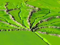
Seven rivers and seven mountains, morning in Mu
Morning in Mu. Now I have added a directional, shadow-casting light
(Sun) and placed it in the east. In this view, we are high above the Rhu
Hut Plains, looking south to the city of Hamukulia and beyond. The Ha
sound means "the breath or spirit of a thing", so Hamukulia would be the
heart of Mu. Rightly so because it is here that civilization began.
In over one half million years since mankind began incarnating in Lemuria,
nobody had ever been to the northeast quadrant, because they couldn't
get up the Clarion Mountains or over the Hatamukulia River. Then, a
group of explorers, led by Rhu and Hut of the Mu Valley, do the
impossible and build a log bridge across the Chiata Pass. You may have
noticed that I've made the grass a little greener on the Rhu Hut Plains.
When the first people moved there, they were impressed by the darker,
bluer color of its expansive grasslands. This "new" grass had much
deeper roots that didn't get pulled up by grazing herds. In this view we
can see all but the Judi, Opu and Beni tribal valleys. Hamukulia is the
hub of the wheel, the crown chakra of Mu.
As a point of reference, I am calling the mountain chain, at the
southern end of the Rhu Hut Plains, the Clarion Mountains. On maps of
the Pacific Ocean floor, this area is known as the Clarion Fracture Zone.
My Lemurian Teachers have said that Clarion was the name of the
planet were Earth's Angels did their Human Phase, in their evolution of
consciousness. So, with everybody's permission, I'd like to continue
calling them the Clarion Mountains. Notice, you can see forest areas in
all of the valleys. I've also added color to the seacoast marshlands,
and took more black out of the mountains.
Home | The Lemuria Mailing List |
FAQ
Maps of Lemuria
Lemuria Books | Lemurian
Resources | Links